Typhoon 'Krosa' and 'Bailu' Expected to Bring Heavy Rain to the Korean Peninsula
Unlike the heatwave that followed the torrential rain in mid-last month, heavy rain is anticipated after the current heatwave.
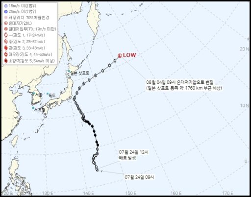
Typhoon No. 9 'Krosa' and Typhoon No. 10 'Bailu' are moving northeast, and heavy rainfall is forecasted nationwide from the night of the 3rd to the 6th.
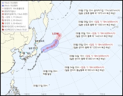
According to the Meteorological Administration, as of 6 a.m. on the 4th, Typhoon Krosa is located approximately 1,700 km east of Sapporo, Japan, with a central pressure of 990 hPa and a maximum wind speed of 86 km/h. Typhoon Bailu is moving northeast with a central pressure of 994 hPa and a maximum wind speed of 65 km/h, located approximately 700 km southeast of Sendai.
As these two typhoons make way, the fragment of the North Pacific High, which has suffocated the Korean Peninsula and caused the heatwave, is weakening and being carried away by the westerlies.
The possibility of extreme rainfall is increasing due to worsening weather conditions.
Afterward, the main body of the North Pacific High, located southeast of Japan, is expected to expand its influence over the southern part of the Korean Peninsula, bringing moisture vapor left by Typhoon No. 8 'Compai' from the south.
Additionally, an extratropical low-pressure system weakened from Compai is expected to pass through the country from west to east, bringing additional moisture from the West Sea.
In particular, the sea surface temperature over the West Sea has reached around 30 degrees Celsius, 1 to 3 degrees higher than usual due to the prolonged heatwave, significantly increasing the amount of moisture supplied to the atmosphere.
Meanwhile, dry air from the Tibetan High is moving south from the north.
The clash between the warm, humid air coming in from the south and the cold, dry air descending from the north is likely to result in extreme rainfall, particularly in the western regions and along the southern coast. It is expected that rain will be particularly heavy at night when the lower-level jet, which blows at around 1.5 km in altitude, strengthens.
Regional Precipitation Forecast and Safety Advisories
On Monday, the 4th, heavy rain is forecasted nationwide, particularly in the Gyeongsang region.
The expected precipitation amount from the 4th to the dawn of the 5th is forecasted to be 5-10 mm for Seoul, Incheon, and western Gyeonggi, 5-30 mm for eastern Gyeonggi and the eastern coast of Gangwon, 10-50 mm for inland and mountainous areas of Gangwon, 10-40 mm for Daejeon, Sejong, and inland Chungnam, and 10-60 mm for Chungbuk, Gwangju, Jeonnam, and Jeonbuk.
In the Busan, Ulsan, and Gyeongnam regions, 30-80 mm is expected (with some areas in Ulsan and eastern Gyeongnam exceeding 120 mm), while Daegu and southern Gyeongbuk are forecasted to receive 20-80 mm (with some areas exceeding 100 mm). In northern Gyeongbuk, Ulleungdo, Dokdo, and mountainous areas of Jeju, 20-60 mm of rain is expected.
Strong rain over a short period may cause sudden flooding, so access to rivers or camping should be avoided.
Furthermore, it is concerning that another round of heavy rain is expected from the 6th to the 7th.
During this time, the warm, humid westerly winds along the edge of the North Pacific High will collide with the cold, dry air descending from the north, likely forming a band-like rain cloud system that brings heavy rainfall.
This rain cloud system is expected to sweep across the country from the central to the southern regions, bringing significant precipitation.
Continued Heatwave Expected Even After Heavy Rain
Areas experiencing heavy rainfall may see heat advisories lifted, leading to a temporary reprieve from the heat, but temperatures are expected to rise again to the point of another heat advisory once the rain stops.
As the influx of warm, humid air continues, the perceived temperature will remain high, and tropical nights are likely to persist.
Meanwhile, according to the daily situation report from the Ministry of the Interior and Safety, 26 people have died and 2 are missing due to extreme rainfall between the 16th and 20th of last month, resulting in a total of 28 casualties.
The number of deceased varies by region, with 13 in Gyeongnam, 8 in Gyeonggi, 3 in Chungnam, and 2 in Gwangju. Currently, there are 1 missing person each in Gyeonggi and Gyeongnam.
As emergency restoration efforts proceed by the government and local authorities, the recovery rate has reached 86%.
However, it is important to note that agricultural lands and crops are excluded from emergency restoration efforts.
Following the heavy rainfall, heat-related illnesses continue to emerge.
On the 31st of last month, 58 people (provisional figure) sought emergency treatment for heat-related illnesses across over 500 hospitals nationwide, including 1 death presumed to be due to heat illness.
Deaths presumed to be related to heat illness have occurred daily from the 27th to the 31st of last month, leading to a total of 18 presumed deaths from heat illness this summer.
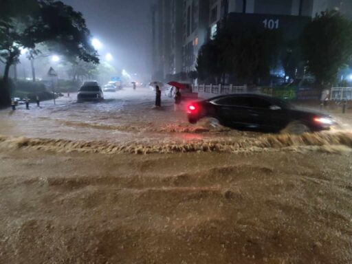
Image source: Route of Typhoon No. 10 'Bailu' / Korea Meteorological Administration, Route of Typhoon No. 9 'Krosa' / Korea Meteorological Administration, As of 8:40 PM on the 3rd, with a maximum of 279.2 mm recorded at Muan Airport, in the midst of heavy rain concentrated in the Muan and Hampyeong areas, a vehicle is passing through a flooded road in Muan-eup. / News1, News1